China launches scientific expedition to investigate ice, carbon storage in Yangtze headwaters
Northwest China's Qinghai province is located in the hinterland of the Qinghai-Tibet Plateau. It is the source of the Yangtze River, the Yellow River and the Lancang River.

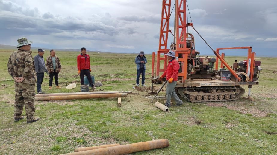
Members of the expedition team launch a field observation experiment in the wetland in the Damqu River basin, northwest China's Qinghai province. The expedition is launched by the Changjiang River Scientific Research Institute under the Changjiang Water Resources Commission, Ministry of Water Resources to investigate the carbon sink potential and carbon storage of the wetland. (Photo from the official website of the Changjiang River Scientific Research Institute)
Dubbed "the water tower of China," the province transmits more than 60 billion cubic meters of clean water resources to downstream areas every year.
A scientific expedition in the headwater regions of the Yangtze and Lancang Rivers was recently launched by the Ministry of Water Resources (MWR) to investigate the regions' water resources and ecological environment. The observation of glaciers and carbon stock of wetlands is a key mission of the expedition.
"This time we will use ground-penetrating radars to measure glacier thickness, and calculate ice volume and its variation based on previous data, to get the volume of the water resource from glacial melt," said Xu Ping, chief engineer of the Changjiang River Scientific Research Institute (CRSRI) under the MWR.
Proceeding with the observation of lakes replenished by glaciers, the expedition aimed at seeking the relation between glacier variation and the water volume of lakes, Xu said.
It will provide basic data and science-based solutions to the prevention and management of environmental risks in the headwater regions, so as to help avoid problems such as desertification of grassland, as well as water and soil erosion caused by water reduction of lakes and rivers, the chief engineer introduced.
Advanced monitoring equipment was employed during the expedition. Hong Xiaofeng, deputy director from the water resources management research office at the CRSRI told People's Daily that a 3D laser scanner was used in the expedition, which has a scanning radius of 6 kilometers and millimeter-level accuracy. It can superimpose measurement results recorded in different periods and then analyze the changes in glacier movement, said Hong, who has joined multiple expeditions to glaciers.

Members of the expedition team take soil samples. (Photo from the official website of the Changjiang River Scientific Research Institute)
A three-dimensional observation system was established, Hong said, adding that it helped acquire data in uninhabited areas and overcome the difficulties of data collection in winter. The system included an unattended meteorological station, a snow analysis system that can transmit temperature, humidity, radiation, and precipitation data regularly, a glacier foreland observation system and other devices.
In the wetland in the Damqu River basin, which has an average altitude of about 4,800 meters, scientists took soil samples through drilling machines and took photos of the area via drones. More than 100 water, soil and vegetation samples were collected.
"The soil showed clear strata and the carbon concentration varied from stratum to stratum; underground roots were around 20 millimeters deep in meadows densely covered by ponds, and the well-developed roots had a strong capability in water and carbon fixation," said Zhao Dengzhong, deputy director of the CRSRI's scientific exchange and international cooperation office.
Carbon sink is a process when carbon is collected and fixed. To improve the capacity of the ecological carbon sink is of great importance for mitigating global climate change. Examining the carbon sink in the headwater regions was also a focus of this expedition.
"We analyzed the variation of carbon distribution at different depths of the soil to find out how carbon storage varies on an annual basis and draw an accurate conclusion of the carbon sink potential in the headwater regions," Zhao said.
Scientists acquired the CO2 and methane contents at the air-water interface and the soil-air interface with trace gas analyzers to obtain carbon flux information from different subsurface. They also made hyperspectral satellite remote sensing images with Beidou satellites and drones, and gradually established a monitoring network, Zhao explained.

Members of the expedition team pose for a group photo. (Photo from the official website of the Changjiang Technology and Economic Society)
"Taking frozen soil as an example, over the recent years, impacted by the warming and humidification of the climate on the Qinghai-Tibet Plateau, a part of the frozen soil would release carbon when melting. This process in turn promotes the reproduction of animals and plants, and thus further enhances carbon sink," Zhao said.
"The research of the carbon cycling mechanism and carbon sequestration potential of the wetland ecological system on the Qinghai-Tibet Plateau is of important significance for ecological protection on the Earth's third pole and for achieving carbon peak and carbon neutrality goals," Xu noted.
The expedition will further the understanding of the current state of the ecological environment in the headwater regions of the two rivers, and will provide basic data for research projects including the protection of the Yangtze River and the construction of the Sanjiangyuan National Park.
Photos
Related Stories
- Cycling event in NW China's Qinghai province stimulates integrated local development
- Summer scenery of Dongge Cuona Lake in Qinghai
- Top legislator highlights ecological protection on Qinghai-Tibet Plateau
- Tibetan macaques seen in forest farm in NW China's Qinghai
- China's Qinghai increases compensation for deaths caused by wildlife
- Scenery of cole flower fields in Qinghai
- China's top political advisor underscores high-standard aid to Qinghai
- Aerial view of world's largest photovoltaic power station in Qinghai
- Kanbula in NW China's Qinghai advances ecological protection and local tourism industry in parallel
- Renewable energy generation projects accelerate construction in Qinghai, NW China
Copyright © 2022 People's Daily Online. All Rights Reserved.


