Digitalization gives leg up to Chongqing's urban management

Photo shows a three-story parking building in Yubei district, southwest China's Chongqing municipality. (People's Daily Online/Long Fan)
Chongqing municipality in southwest China, a city located on hills, is the largest city in China by both total area and population. With complex landforms and plenty of bridges and tunnels built on and in the hills, the city is confronted with tricky challenges in urban management such as frequent natural disasters, various risks in urban operation and difficulties in risk prevention.
In recent years, Chongqing has worked in a systematic manner to build itself into a safe city, constantly improving its level of modernization in urban safety governance.
Chongqing always becomes rainy when spring ends. In the gardens in the phase-IV section of the Donglindao residential complex in the city's Bishan district, flowers and plants were wet by raindrops, but the paths remained dry.
Shen Xiaofeng, who lives in the residential complex, told People's Daily that in the past, these paths would be slippery and logged on rainy days, and thanks to a sponge city construction program, it's difficult to see standing water in the residential complex today.
The designer of the sponge city construction program Wu Yizhou said that during the renovation, sponge facilities were designed as a part of the garden view.
According to Wu, gardens and permeable pavements are distributed throughout the residential complex. On rainy days, the rainwater does not directly flow into the drainage system from the sidewalks. Instead, it first enters the gardens or permeable pavement areas for retention and infiltration, and excess rainwater flows into the municipal drainage network or storage tanks.

Photo shows the sports field of a renovated residential complex in Ba'nan district, southwest China's Chongqing municipality. (People's Daily Online/Li Pan)
Therefore, the rainwater is stored, infiltrated and purified naturally, which not only effectively utilizes water resources, but also alleviates the urban heat island effect, Wu said.
Zou Xiaochun, an official with the housing and urban-rural development department of Chongqing, noted that in recent years, Chongqing has built 34 typical drainage zones and 122 typical source reduction projects in various districts and counties based on local conditions, which form a sponge city system that suits different landforms including mountainous areas, deep canyons, hills, and flat terrains.
On Aug. 29, 2021, a rock collapse occurred in Guanmiao community, Guanmian township, Kaizhou district of Chongqing. Thanks to an early warning system, 93 people from 37 households were evacuated in advance, and no casualties were reported.
At 10:00 am on Aug. 30, 2022, signs of a landslide were detected in Heping village, Wenquan township, Kaizhou district. A prompt assessment was quickly released through an intelligent early warning information platform, and an alert plan was automatically generated by 10:30 am. The local government immediately designated the danger zone, launched emergency control measures and evacuated residents. At 12:30 pm, a landslide occurred.
Both of the two natural disasters occurred without causing any casualties, which is attributed to the effective intelligent early warning management mechanism adopted by Kaizhou district.
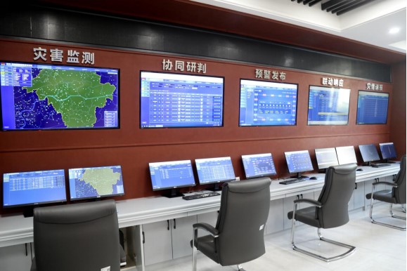
"In 2021, by comprehensively reviewing the risk points, affected populations, and designated early warning personnel in disaster-prone areas, we fully upgraded our intelligent early warning information release platform," said Xi Shui, deputy director of the emergency management bureau of Kaizhou district.

Photo shows an intelligent early warning information platform in Yunyang county, southwest China's Chongqing municipality. (Photo from the public account of the publicity department of Yunyang county on WeChat)
"Once a disaster threshold is reached, the platform automatically matches corresponding instructions and recipient groups. It then immediately and simultaneously pushes out precise warning notifications through district-wide broadcasts, TV, large screens, and online applications, ensuring widespread and synchronized dissemination of alerts, Xi explained.
It is reported that in 2023, Kaizhou district released over 15,000 warning messages of various types to more than 1.3 million recipients. Additionally, 18 important warning messages were broadcasted through an "emergency loudspeaker," reaching a total of 66,000 people.
Located at the confluence of the Jialing, Fujiang, and Qujiang Rivers, Chongqing's Hechuan district has a large water surface area and high annual water flow, resulting in frequent natural disasters like floods and geological hazards.
To precisely locate the areas that might be inundated during floods and the safest evacuation paths, the flood and drought disaster prevention and control center of Hechuan district created a digital 3D flood simulation model based on Hechuan district's topography and terrain maps after spending a year conducting field research and consulting hydrological data. The model includes flood risk maps from three sub-district offices in the main urban area and nine key places along the rivers, as well as a flood operation map for the main urban area.
"This model can dynamically simulate the inundation areas as water levels rise from 0 to 200 meters, with an accuracy within 1 meter. It can precisely calculate the number of people needing evacuation and designated shelters at different water levels, specifying the responsible personnel, community contacts and other key information," said Wu Zuhua, a staff member of the Luoyangxi community committee in Heyangcheng sub-district.
Nowadays in Chongqing, water and power systems, bridges, tunnels, rail transit, and utility networks have all been integrated into a digital city operations and governance center, which functions as an intelligent brain of the city, enabling intelligent perception of operational risks. It assists decision-making for city management authorities through digitized means, continuously driving the modernization of governance systems and capabilities.
Photos
Related Stories
- SW China's Chongqing preserves charm of Ciqikou ancient town in urban renewal
- Digitalization drive helps advance modernization of social governance in Chongqing
- China (Chongqing) Pilot Free Trade Zone supports Chongqing in building hub for inland opening-up
- Letter from China: Breathing new life into old neighborhood
- SW China’s Chongqing steps up efforts to crackdown on intentional spreading of HIV/AIDS
Copyright © 2024 People's Daily Online. All Rights Reserved.


